
HOBO-DYER EQUAL AREA PROJECTION
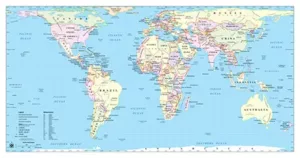
The Hobo-Dyer equal area global map, designed to reshape worldwide perspectives, reveals accurate size comparisons while challenging the conventional North-South orientations. Conceived by ODT, Inc., this map projection draws inspiration from the Peters equal area concept but is designed to minimize distortion of both size and shape of land masses, providing a more accurate representation of the relative sizes of countries and continents compared to traditional map projections.
Its origins trace back to modifications of the 1910 Behrmann projection. Behrmann’s projection featured standard parallels situated at 30° north and south. In a stark deviation, the Hobo-Dyer projection assumes a cylinder that wraps around the globe, intersecting it at 37½° north and south.
In 2002, the Hobo-Dyer Map was commissioned by Howard Bronstein (Ho), Bob Abramms (Bo) of ODT, Inc., and expertly drawn by cartographer Mick Dyer of Oxford Cartographers.
To offer a fresh viewpoint, ODT printed the Hobo-Dyer map on both sides, one with the conventional north orientation and the reverse featuring the south on top. This subtle geographic shift encourages viewers to confront inherent biases and question how maps influence their perception of the world.
Here are some key details about the Hobo-Dyer Equal Area Projection map:
- Equal Area Projection:
- The primary feature of the Hobo-Dyer projection is that it maintains equal area properties. This means that the sizes of land masses on the map are proportional to their actual sizes on the Earth’s surface. This is particularly important for accurately representing the relative size of continents and countries.
- Cylindrical Projection:
- The Hobo-Dyer projection is a cylindrical equal area projection. It projects the Earth’s surface onto a cylinder, which is then unrolled to create a flat map. This is a common method used in cartography to create world maps.
- Distortion:
- While the Hobo-Dyer projection minimizes distortion in terms of area, it does introduce distortion in terms of shape and direction. Like many equal area projections, shapes near the poles may be distorted, but this is a trade-off for maintaining accurate area representation.
- Centered on the Prime Meridian:
- The Hobo-Dyer projection is centered on the Prime Meridian, which runs through Greenwich, London. This means that the eastern and western hemispheres are split along this meridian.
- Representation of North and South Poles:
- The map also attempts to represent the North and South Poles in a way that avoids the typical distortion seen in other map projections.
- Social Justice Aspect:
- The Hobo-Dyer projection is notable for its social justice aspect. It was created with the intention of providing a more equitable representation of the world, challenging traditional maps that often exaggerate the size of wealthy, northern countries at the expense of poorer, southern countries.
- Use in Education:
- The Hobo-Dyer projection has been used in educational settings to promote a more accurate understanding of global geography, emphasizing a balanced representation of countries and continents.
- Global Attention:
- The Hobo-Dyer map projection garnered global attention when President Jimmy Carter utilized it to illustrate his agency’s international efforts during his Nobel Peace Prize ceremony in December 2002. The map delineated the global locations of the Carter Center, cementing its unique place in cartographic and geopolitical history.
Keep in mind that map projections involve compromises, and different projections serve different purposes. The choice of a particular projection depends on the specific requirements and priorities of the mapmaker or user. The Hobo-Dyer Equal Area Projection is just one example of attempts to create a more socially and geographically equitable representation of the world.
We offer a variety of options for the Hobo-Dyer Equal Area Projection!
You can choose from North or South up, detailed or simple cartography and offered in English, Chinese, Portuguese or Spanish.
Hobo-Dyer Equal Area Map
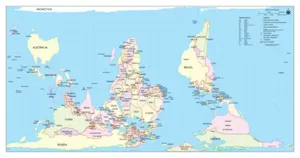
Hobo-Dyer Upside Down Equal Area Map
FAQ
- Why should I choose the Hobo-Dyer Equal Area Map over other world maps?
The Hobo-Dyer Equal Area Map is preferred by many because it accurately represents the relative sizes of landmasses without distorting them. Unlike traditional Mercator projections which exaggerate the sizes of landmasses near the poles, the Hobo-Dyer World Map provides a more equitable portrayal of the world. This makes it particularly useful for educational purposes, social justice initiatives, and for gaining a more accurate understanding of global geography. - What is the significance of the “equal area” aspect of the Hobo-Dyer Map?
The term “equal area” in the Hobo-Dyer Map refers to its cartographic projection, which ensures that each region’s size on the map accurately reflects its true relative size on the Earth’s surface. This means that areas that are typically distorted, such as Greenland appearing larger than Africa on traditional maps, are accurately represented in terms of their actual land area. This characteristic is especially important for understanding and addressing issues related to social justice, resource distribution, and global representation. - Can the Hobo-Dyer Map be used for navigation purposes?
While the Hobo-Dyer Map provides an accurate representation of the relative sizes of landmasses, it may not be the most suitable choice for navigation purposes, particularly for long-distance travel. For practical navigation, many still prefer the Mercator projection due to its preservation of angles and shapes, which aids in plotting courses accurately on a map. However, the Hobo-Dyer World Map serves as a valuable educational tool and for raising awareness about global inequalities in representation and resource allocation.
 Hobo-Dyer Map