Promote Health & Well-Being by Implementing a Cycle Route Map in Your Local Community
Cycling is an easy and fun way for riders to get their daily dose of exercise, see the sites and enjoy the fresh air. Not only that but it has also been proven to benefit both mental and physical health. We could all do with a little more of that. So why not encourage more people in your local community to cycle by developing a cycle route map?
In Aberdeen and South Warwick, we have supported the councils in initiatives to reduce emissions and encourage more active transport.
Aberdeen’s GetABout cycling and walking project went beyond cycle paths to encourage multimodal travel. They wanted to design realistic alternatives to driving, including walking or cycling, whether for the entire trip or just to public transportation stops.
More than a tourist guide or leisurely health promotion, the cycle route and map had to be interactive, with pan and zoom mapping functionality. Widescale adoption and measurable emission reduction were key to the initiative. It was integral to their broader user experience vision that the map could include links to external journey planners, including Traveline Scotland, where they could easily plan their entire route – on foot, bike or public transport. For true adoption success, the map had to be able to be advertised by use of QR codes placed on signs and way markers on the route.
Oxford Cartographers worked with Aberdeenshire Council to build out the interactive map, including the integration features with other journey planners, online interactivity, and offline printed maps with easy-to-read and understand markers.
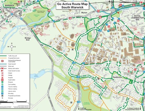
For South Warwick, there were both existing routes and proposed cycle paths worked into the finalised route map. Collaboratively we worked with the council to gather their route data, both established and new, before our team took the information and physically drew the route onto the map. This may sound simple, but accuracy is of the utmost importance to ensure the safety and overall experience of cyclists. Mistakes can be costly and damage council reputations.
In both instances and generally in all of our services, Oxford Cartographers deliver versatile map solutions with physical printed leaflets as well as digital and interactive maps. The bespoke nature of our map-making capabilities allows councils and community leaders to design initiatives with endless possibilities. You could introduce a treasure trail to capture the excitement and imagination of the town. The project could be tied to serious emission reduction targets, or it could simply be to offer the community a guide on new ways they can commute or explore their locale.
To explore what you can do with a cycle route map of your shire, contact Oxford Cartographers. your UK map specialists. We make wall maps, town centre maps, promotional maps, diary maps, interactive maps and more.